GSSI SIR-3000 400MHz Antenna for sale, included Cart, Radan 7 Software, ready to working order on the field, complete package GSSI SIR-3000, 400MHz Antenna
Product Description
Box with Antenna and wheel
GSSI 400 MHz – Shielded Antenna
The GSSI 400 MHz Model 50400S antenna has greatly improved resolution performance over previous GSSI mid-frequency antennas, such as the Model 3105 (300 MHz). The Model 50400S can be used in continuous, survey wheel or static stacking modes. The 400 MHz antenna is ideally suited for detection and mapping of utility pipes, void detection, tunnel voids, and archaeological applications. This antenna is compatible with all GSSI control units.
Smart Antenna: The Model 50400S is a 400 MHz “smart” antenna. This antenna has a special chip in it that will work with the SIR-30 and future control units (not the SIR-3000 or SIR-20). This chip will identify the antenna to the SIR-system control unit so that the controller will be able to automatically load up the correct default settings. The 50400S will function with a SIR-3000, SIR-20 or any of GSSI’s previous controllers, but the user will need to manually set the collection parameters on the SIR-system.
Specifications
| Center Frequency | 400 MHz |
| Depth Range | 0-4 m (0-12 ft) |
| Weight | 5 kg (11 lbs) |
| Dimensions | 30x30x17 cm (12x12x6.5 in) |
| Model | 50400S |
GSSI SIR 3000 Accurate GPR Controller
The SIR-3000 is the industry’s number one choice for data accuracy and versatility. This small, lightweight control unit is designed for single-user operation. The SIR-3000 provides the essentia features and flexibility that experienced GPR users require, as well as simplified, application-specific user interfaces for novice GPR users. The SIR-3000 incorporates advanced signal processing and display capability for ‘in-the-field’ 3D imaging. Unlike other data acquisition products on the market, the SIR-3000 is interchangeable with all GSSI antennas, making it an affordable and flexible option for multi-application users.
The success of the SIR 3000 data acquisition system results from GSSI’s 40 years as the world leader in the development and sale of ground penetrating radar. The SIR 3000 is the tool of choice when you need to make sure that your valuable research dollars are well spent. The 3000 sets the standard for small size, lightweight and rugged reliability while delivering superb data quality under tough field conditions. It can run most of GSSI’s huge variety of antennas and connects to GPS devices. When your project calls for non-invasive, fast, high-quality GPR survey results, turn to the SIR 3000. Once you see how easy the instrument is to use and transport, you’ll wonder how you did fieldwork without GPR.
Typical Uses
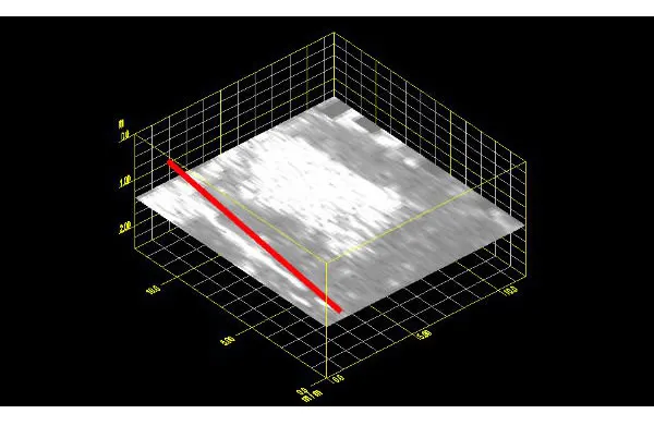
Environmental Assessment: Site Assessments: Environmental scientists and land developers use GPR and EM to assist in their redevelopment efforts. These proven geophysical methods allow professionals to conduct a non-intrusive investigation of the surface at a relatively low cost. This data below shows a clearly defined boundary of potential toxic chemicals. the Red line is a pip that runs along the left of the data set. This data was collected with a SIR 3000 and 400 MHz antenna. Data is shown in RADAN 7

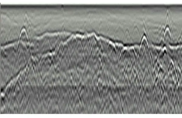
Environmental Utility Locating: Drilling Clearance: GPR can detect what lies beneath the surface before drilling and trenching efforts. GPR technology allows users to safely identify subsurface features and utilities, and avoid costly or dangerous hits. Data set shows three utilities at varying depths. Utilities are located just above a clearly defined bedrock horizon. This data was collected using a SIR 3000 with a 400 MHz antenna.

Specifications
| System | |
| Antennas | Compatible with GSSI Analogue antennas |
| Number of Channels | 1 (one) |
| Data Storage | Internal memory: 2 GB Flash memory card Compact Flash port: Accepts CF memory up to 8 GB (using FAT 16 file format) |
| Display Enhanced | 8.4: TFT, 800×600 resolution, 64K colors |
| Display Modes | Linescan, O-scope, 3D |
| Data Acquisition | |
| Data Format | RADAN (.dzt) |
| Scan Rate Examples | 220 scans/sec at 256 samples/scan, 16 bit 120 scans/sec at 512 samples |
| Scan Interval | User-selectable |
| Number of Samples per Scan | 256, 512, 1024, 2048, 4096, 8192 |
| Operating Modes | Free run, survey wheel, point mode |
| Time Range | 0-8,000 nanoseconds full scale, user-selectable Gain: Manual or automatic, 1-5 gain points (-20 to +80 dB) |
| Filters | Vertical: Low Pass and High Pass IIR and FIR Horizontal: Stacking, Background Removal |
| Languages | English, French, Italian, German, Spanish, Japanese, Chinese |
| Operating | |
| Operating Temperature | -10°C to 40°C ambient |
| Charger Power Requirements | 15 V DC, 4 amps |
| Battery | 10.8 V DC, internal |
| Transmit Range | Up to 100 KHz |
| Input/Output | |
| Available Ports | Antenna input DC power input Serial RS232 (GPS port) Compact Flash memory USB master slave |
| Mechanical | |
| Dimensions | 12.4 (l) x 8.7 (w) x 4.1 (h) in (31.5 x 22 x 10.5 cm) |
| Weight | 9 lbs (4.1 kg) including battery |
| Environmental | Water Resistant |
Documentations